


 Two fundamentally different methods EDF is using to measure and understand methane emissions in the Permian Basin are producing strikingly similar results. The mutually reinforcing sets of data — one gathered using aircraft, the other by satellite — each show that oil and gas operators in the region are releasing more than 3.5% of the natural gas they extract from the ground into the atmosphere as methane pollution.
That’s roughly twice the average rate found in 11 other major U.S. oil and gas basins. The wasted gas in the Permian is enough to supply 2 million American homes for a year.
The first of these efforts is EDF’s year-long PermianMAP, which tracks emissions from the ground and in the air, and takes the unprecedented step of publishing data online in near-real time to help industry and officials reduce those emissions, while letting the public see the results. The other is the first peer-reviewed scientific study to take direct measurement of Permian emissions, using the European Space Agency’s TROPOMI instrument.
These two studies provide the most comprehensive assessment yet of the region’s methane emissions. Both sets of data show the highest methane emissions ever measured from a major U.S. oil and gas basin. Methane is a highly potent greenhouse gas, and the effect of these extreme emissions nearly triples the 20-year climate impact of Permian gas used for purposes such as power generation or household cooking and heating.
Unprecedented earthbound measurement
PermianMAP combines a suite of established, peer-reviewed data collection methods with state-of-the-art technologies to pinpoint, measure and report oil and gas methane emissions in the Permian. Data is collected three ways: with aircraft (fixed-wing and helicopters), mobile labs driven to sites throughout the region, and from monitors mounted atop five stationary towers.
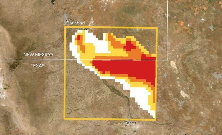
However you measure it, Permian oil and gas operations have highest emissions ever measured in a U.S. oilfield Share on XMeasurement sites are spread across a 10,000-square-kilometer study area of the Delaware Basin, a subsection of the broader Permian region that produces roughly 40% of its oil and gas. Sites are selected using a random sampling protocol to avoid selection bias. This ensures data is fully representative of both high- and low-emitting sites throughout an area encompassing much of the basin’s production.
PermianMAP data collection methods offer a dynamic view of emissions, both at specific points in time and over longer durations. Aircraft and mobile lab surveys provide a discrete look at emissions, while other methods — such as the five stationary towers — will measure methane continuously and track emission fluctuations over 12 months. Additionally, the fact that repeat samples will be taken of emission sites over the course of the study means the project will allow us to spot trends and deliver insights over time, while also tracking how operator performance improves.
Verified and transparent
PermianMAP methods are verified through an independent advisory panel including scientists from Stanford University, McGill University, Colorado State University and the University of Michigan. Because the project aims to turn data into action, findings are shared as quickly as possible through an online dashboard — enabling operators, regulators and the public to track performance and the location of measured emission events.
This will be critical as policymakers in New Mexico and Texas consider regulatory improvements to curb methane waste and pollution, after decades of lax oversight allowed the region’s emissions problem to grow unchecked.
Building on EDF’s extensive history in conducting methane science in partnerships with research institutions, oil and gas operators, and others, we have also dedicated significant time to understanding companies’ concerns, needs and priorities surrounding the data we’re collecting and how we present it. To make the data more fully actionable, we share it directly with companies and regulators as soon as it is quality assured. And our online platform lets producers share observations about the emissions events we report on, along with any actions they take to address them.
To prioritize the safety of oilfield workers and nearby residents, we immediately report any leaks that might pose an imminent health or safety risk to the relevant authorities.
Data collection for the project will continue through 2020, and initial results released on April 7 reveal the study region is emitting 3.5% of the natural gas it produces — over 10 times higher than the reduction targets set by leading energy producers.
In alignment with standard industry and academic practices, the leak rate is calculated as total emissions over natural gas production. This allows companies with methane targets, investors and policymakers to properly benchmark performance.
Satellite study confirms massive leak rate
While the earthbound measurement approaches used by PermianMAP offer a granularity that can pinpoint emissions from individual sites or clusters of them — in addition to identifying specific sources via infrared camera — satellite observations can survey larger areas with high frequency, and track changes in emissions from both known and previously unknown sources.
Satellite data takes methane research to a whole new level of detail and sophistication. Not only can it be used to analyze hard-to-reach regions or areas researchers don’t have access to, but also to evaluate the findings of earthbound observation methods.
A study conducted by scientists from EDF, Harvard University, Georgia Tech and the SRON Netherlands Institute for Space Research and published in the April 22 edition of the journal Science Advances analyzed satellite data collected over the Permian Basin by the European Space Agency’s TROPOMI instrument between May 2018 and March 2019.
In total, 200,000 individual satellite readings taken across the entire basin revealed a 3.7% methane leak rate, notably similar to the 3.5% leak rate seen in the PermanMAP measurements. Taken together, the findings resulting from each generate data at different spatial and temporal scales, and validate one another.
As technology and data analysis tools evolve, the next generation of satellites will have even higher precision and greater capabilities. For example, MethaneSAT — being developed by EDF subsidiary MethaneSAT LLC — will track oil and gas methane worldwide on a near-weekly basis and be able to find and measure smaller emissions from more dispersed sources that current systems can’t.