New mapping tool could help communities, policymakers prioritize clean transportation solutions
Written By
Share
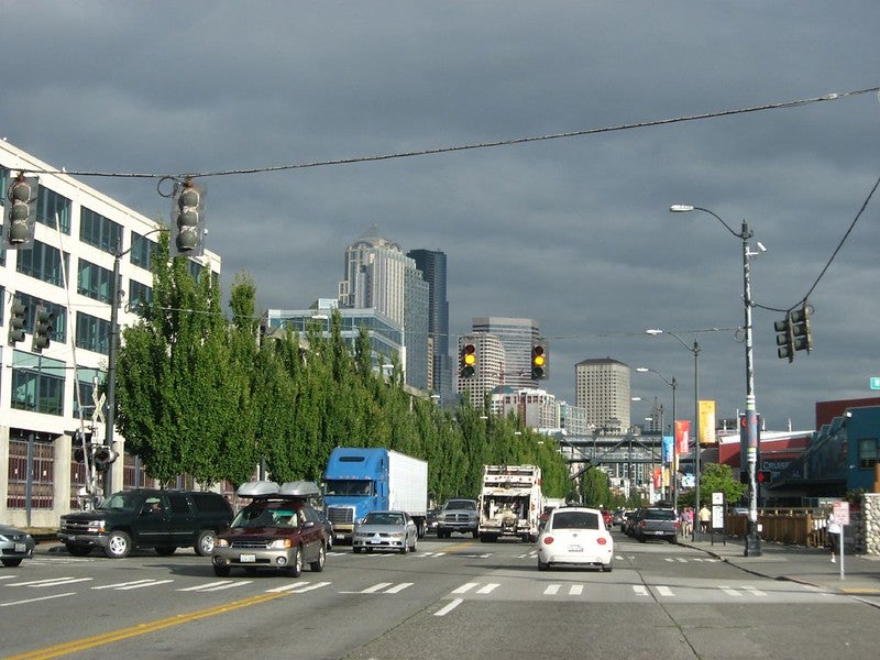 My children’s daycare, which is on a commercial strip between supermarkets and restaurants, often has three refrigerated trucks idling outside the front door. These diesel trucks can emit harmful pollution, even when they aren’t moving. The impact of transportation pollution on vulnerable populations is often striking. In downtown Oakland, where more than 70% of the population are people of color, one in two new cases of childhood asthma are attributed to transportation pollution.
Companies are being questioned about the impacts that truck-attracting facilities like warehouses are having on local communities. The pressure will only increase as e-commerce and distribution facilities expand right by population centers.
Now, a new methodology from Environmental Defense Fund called Proximity Mapping helps identify the communities living close to warehouses and distribution facilities — businesses that are often truck magnets. The tool integrates social, demographic and health information for people living within half a mile of a truck-attracting facility. As a result, the tool can visualize the disproportionate proximity of low-wealth communities and Black, Asian-American, Latino and Indigenous communities to areas where trucks gather and provide additional data support to an issue that many communities have been raising for decades. It also shows that, when compared to state and national averages, some communities living around truck areas disproportionately suffer from health conditions that can be made worse by pollution from trucks, such as asthma, chronic heart disease, chronic obstructive pulmonary disease and stroke.
New mapping tool could help communities, policymakers prioritize clean transportation solutions Share on XNeighbors are at risk
The unequal danger from diesel trucks is more visible than ever. Despite being only 4% of the registered vehicles in the U.S., diesel vehicles are responsible for 60% of the air quality health impacts from all cars and trucks. Because of redlining, racist highway construction and other policies and practices, warehouses were built beside and inside Black and Latino communities, with dangerous consequences. Regardless of their state or income, Black residents are exposed to 26% higher levels of soot from heavy-duty diesel trucks than the national average. Once exposed, they are then at a three times higher risk of dying.
EDF used a commercial database to identify warehouse locations. We then assessed the demographics and health status of surrounding communities. This analysis confirmed what warehouse neighbors have been saying about the disproportionate risk from warehouses.
- In North Carolina, our dataset shows 560,000 people living within a half mile of an identified warehouse, 40,000 of whom are children under five years old. In the 10 census tracts with the highest rates of asthma, warehouse neighbors have asthma rates 30 – 45% higher than the state average. In the top 10 warehouse-adjacent census tracts for stroke, warehouse neighbors have already suffered strokes at least twice the rate of the state average.
- In Illinois, the dataset shows almost 2 million people living within a half mile of an identified warehouse, 138,000 of whom are children under five. Warehouse neighbors are twice as likely to be Hispanic or Latino as the state average.
- In Texas, 2.2 million people live within a half mile of an identified warehouse, 166,000 of whom are children under five. Warehouse neighbors are 40% more likely to be Black than the state average, and 30% more likely to be living in poverty.
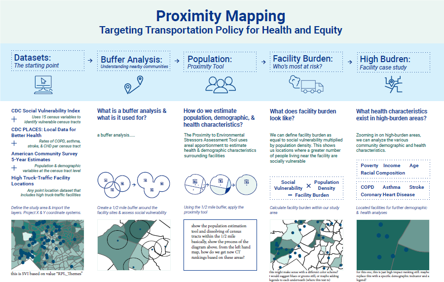
How Proximity Mapping works
The methodology used to create the proximity maps builds on previous tools, such as EJSCREEN or CalEnviroScreen. What is new about Proximity Mapping is the inclusion of health data specific to conditions that are exacerbated by truck pollution. It also enables comparing facilities in a set to one another based on demographic and health characteristics of neighbors, and comparing neighbors around a set of facilities to state or national baselines.
The bridge to solutions
Proximity Maps can be a great tool for community, government and corporate leaders to start integrating health and equity into transportation planning decisions, such as where to prioritize truck charging infrastructure and distribution of EV vouchers.
Proximity Mapping could be used to prioritize deployment of clean transport and clean energy investments in communities most burdened by truck pollution. Some policies that could support this goal include:
- Incentivizing utilities to build out medium- and heavy-duty truck charging infrastructure in neighborhoods at greater risk from truck-attracting facilities.
- Increasing funding for zero-emission vehicle purchases and prioritizing investments in EV workforce development in neighborhoods at greater risk from truck pollution.
- Issuing maps of high-impact neighborhoods so the private sector can prioritize deploying EVs in neighborhoods at greater risk from truck pollution first.
- Designing finance programs and access to financing so that low-wealth and Black, Asian-American, Latino and Indigenous communities can be part of the clean transportation revolution.
- Giving neighbors of warehouses an equitable role in decision-making, planning, permitting and other processes.
We’re working with partners to refine the Proximity Mapping analysis and test ways Proximity Maps could be used. We look forward to working with community-based organizations, government leaders and corporate fleets to identify where and how this new tool might be useful in accelerating efforts to reduce pollution in communities across the country. Since the analytic framework could be used to describe neighbors of any kind of facility, the lessons learned may advance climate, health and equity advocacy around other kinds of emissions sources.
As air pollution becomes more strongly linked to harms at all stages of life — from preterm birth to dementia — the importance of empowering neighbors of polluters is ever more clear.