EDF Health

Selected tag(s): Mapping

Mapping Lead: New Jersey State map as a backbone for real progress on lead

Tom Neltner, Senior Director, Safer Chemicals Initiative and Roya Alkafaji, Manager, Healthy Communities

What Happened: The State of New Jersey published an interactive map showing potential sources of lead exposure for any given address in the state. Currently, the map specifically looks at lead-based paint in housing, though the State has plans to expand this to include other sources of lead, including drinking water from lead service lines (LSLs).

Why It Matters: The availability of address-specific information is important to engage residents, potential home buyers, and renters so they can make better informed decisions about protecting their families from harmful lead exposure. New Jersey is the first state to move beyond neighborhood-level mapping of lead risks to provide specific information about lead at the address level.

The map uses housing age as an indicator to assess risk to lead exposure, which is an excellent place to start because it is relevant to the prevalence of both lead-based paint and lead in drinking water.

As more information is added on lead pipes, lead-contaminated soil, and nearby commercial operations that release lead, as well as details on lead poisoning prevention requirements, the map will become a critical tool in the effort to comprehensively consider lead risks and drive exposure closer to zero.

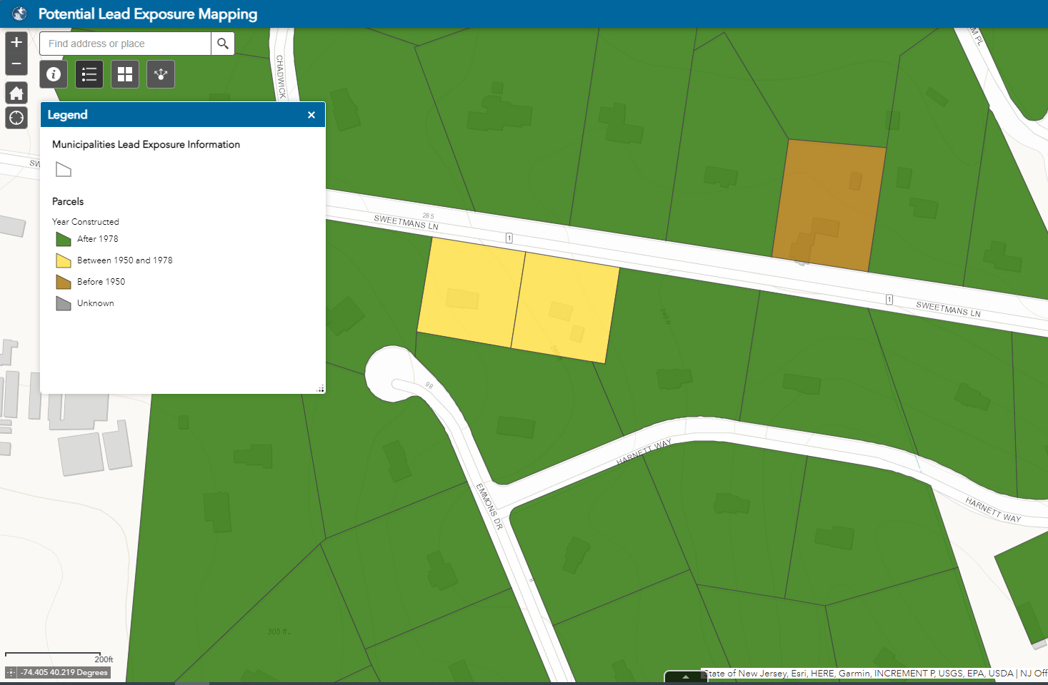
Source: New Jersey Department of Environmental Protection Potential Lead Exposure Mapping (click on Lead-based paint tab at the top and zoom in until you see parcel-level detail with color overlays)

Read More »

Posted in Mapping Lead / Also tagged , , , | Authors: / Comments are closed

Cincinnati and Ohio show leadership in identifying and disclosing lead service lines

Tom Neltner, J.D.is Chemicals Policy Director

Transparency is an essential aspect of any successful program to reduce lead in drinking water. Knowing if you have a lead service line (LSL)—the pipe that connects the main under the street to the building—can help you decide whether to use a filter or replace the line. If you are looking for a home to rent or buy, the presence of a LSL can be a factor in your choice. Transparency can also help reassure consumers that their utility is aware of the problem and committed to protecting their health. The challenge for many water suppliers is that they often don’t have perfect information about the presence of LSLs. But incomplete information is not a reason for failing to disclose what is known, what is uncertain, and what is unknown.

In a February 29, 2016 letter to the states, U.S. Environmental Protection Agency (US EPA) asked states to increase transparency by posting on either the state’s website or have it posted on local utilities’ websites:

“the materials inventory that systems were required to complete under the [Lead and Copper Rule] including the locations of lead service lines [LSLs], together with any more updated inventory or map of lead service lines and lead plumbing in the system.”

In response to this letter and systemic issues brought to light about lead in drinking water in the village of Sebring, Ohio and Flint, Michigan, the State of Ohio enacted pragmatic legislation crafted by Governor John Kasich’s administration and the Ohio Environmental Protection Agency (Ohio EPA). Among its supporters was the Ohio Environmental Council. One provision in the law requires community water systems to

“identify and map areas of their system that are known or are likely to contain lead service lines and identify characteristics of buildings served by the system that may contain lead piping, solder, or fixtures . . .”

Utilities must submit the information to Ohio EPA as well as the departments of Health and of Job and Family Services by March 9, 2017 and update this information every five years.

Read More »

Posted in Drinking water, Lead, Regulation / Also tagged , , , , , , , | Authors: / Read 2 Responses