Traffic pollution causes 1 in 5 new cases of kids’ asthma in major cities: How data can help
Written By
Share
Dr. Ananya Roy is a Senior Health Scientist
[pullquote]
City leadership can ill afford to ignore this issue and must strive for opportunities to prevent new cases of asthma.
[/pullquote]
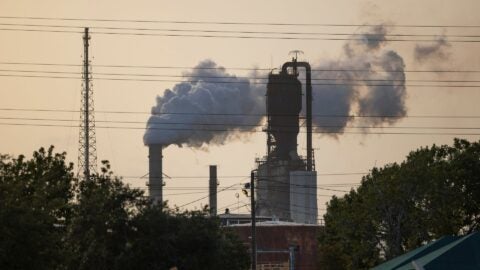
A landmark new study shines a light on the massive impact of vehicular air pollution on the health of our children. The study estimates that nitrogen dioxide (NO2) – a key traffic air pollutant – leads to approximately 4 million new asthma cases in children across the globe, or 1 in 10 new cases.
To address this pervasive threat, leaders need local data to create targeted approaches and policies. That’s why Environmental Defense Fund (EDF) is leveraging sensor technology to develop novel methods to measure and map air pollution – including NO2 concentrations – block by block in cities across the world, from Oakland to Houston to London.
Cities bear the worst burden
The study, released this month in The Lancet Planetary Health, finds that children living in cities are most at risk of asthma due to NO2 pollution. A staggering 90% of all new cases due to traffic were in urban and adjoining suburban areas.
Cities with unbridled growth in traffic and high population exposures to NO2 – such as Beijing, Lima, Bogota and – are among the most affected. But this problem is not restricted to the rapidly-expanding metropolises in lower and middle income countries.
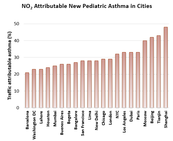
In wealthy cities like London, New York and Houston, NO2 contributed to more than 1 in 5 of all new cases of asthma among children. And these cities are already overburdened by asthma. In New York and London respectively there are 84,000 and 240, 000 children living with asthma. It is the leading cause of chronic health problems among children and asthma costs the US economy $81 billion a year.
City leadership can ill afford to ignore this issue and must strive for opportunities to prevent new cases of asthma.
Data can drive solutions across cities
“Previous global estimates of impacts of air pollution have not adequately accounted for the impact of traffic because they didn’t capture high near roadway exposures. Our study estimating the impacts of NO2 on pediatric asthma was the first to resolve high concentrations near roadways, allowing us to see the impact on children in cities. Yet uncertainties remain,” said Susan Anenberg, associate professor of environmental and occupational health at Milken Institute School of Public Health, George Washington University and the paper’s senior author.
NO2 concentrations change dramatically street by street and block by block, with the variation influenced by intensity of traffic, congestion, and types of vehicles on the streets. The Lancet study uses state-of-the-art modelling techniques with information from satellites, geographic variables and regulatory monitors, but still was able to only partially capture the distribution of NO2 exposures.
“I think there is huge opportunity for mobile monitoring and new citizen science monitoring data. Our global estimates should be seen as a starting point for documenting within city traffic air pollution concentrations. Highlighting local hotspots, unique local sources, temporal variation in levels, and additional traffic-related air pollutants would be important contributions,” said Dr. Perry Hystad, one of the authors of the study.
City and transportation planners require detailed information on where pollution hotspots are in their cities. EDF’s efforts to measure and map exposure to air pollution where people live work and play can help.
Oakland insights
For example, the insights EDF gathered from hyperlocal monitoring proved critical to understanding pollution in West Oakland, CA. Sandwiched between two highways and a major container port, this neighborhood’s rate of emergency room visits due to asthma is more than double the state average. Almost 25 percent of the student body in the West Oakland Middle School has asthma or other breathing problems.
EDF’s advanced air-pollution sensors found that NO2 levels within neighborhoods varied by more than 8 times from block to block. Some of the areas with elevated levels were truck routes or abutted businesses that attracted trucks. Community advocates are now working with regulators and city officials to investigate areas of elevated pollution identified using our data and put in place mitigation strategies, such as increased enforcement of truck prohibited routes.
Policies and actions that address transportation can have synergistic benefits, from reducing traffic and air pollution to improving health and the climate. Cities are taking the lead in this issue, including London’s newly launched Ultra Low Emission Zone and congestion pricing in New York City – policies that will help cut traffic emissions and clean the air.
With better and more accurate data, cities and leaders can go further and design targeted policies to maximize benefits, building healthier communities for everyone.
*Public dataset available at: http://www.thelancet-press.com/embargo/pollutionasthma.xlsx