EDF Health

Breathing wildfire smoke: A scientist mom’s concerns

This post originally appeared on EDF Voices

Maria Harris is an Environmental Epidemiologist.

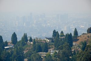
Downtown Oakland, CA skyline obscured by wildfire smoke. Aug. 22, 2020 Photo by Jose Carlos Fajardo, Getty Images.

If the risks, hardships and anxiety of life during a pandemic were not enough, my fellow northern Californians are now facing another health crisis.

As I write this, hundreds of wildfires are burning across the state, among them two of the largest ever in California. Together, the fires have burned more than 1.4 million acres, destroyed 2,800 homes and buildings, killed eight people and forced thousands to evacuate their homes.

On top of the acute risks to lives and homes, residents across the state are suffering from highly polluted air as massive plumes of smoke fill the skies above our homes.

Children, seniors and those with lung disease are especially vulnerable

As a mom of two young kids, it’s been a tough couple weeks of anxiously monitoring air quality data and maps to determine if and when it might be safe to go outside, while seeking information on how to keep my family healthy.

As an environmental health scientist, I know that wildfire smoke has been linked to a range of negative health impacts, including asthma exacerbation, which can lead to emergency room visits and hospitalizations, along with increased rates of heart attacks and even death. Children and pregnant women, as well as those with heart disease or respiratory conditions like asthma, are particularly vulnerable to the health impacts of wildfire smoke.

Read More »

Posted in Air pollution, Climate change, Extreme weather / Tagged , | Comments are closed

What dense sensor networks can teach us about air pollution

Maria Harris is an Environmental Epidemiologist.

It all started with a challenge in 2013: how to engineer pollution-sensing balloons. Thomas Kirchstetter, Adjunct Professor at the University of California, Berkeley and the Director of the Energy Analysis and Environmental Impacts Division at Lawrence Berkeley National Lab, wanted to attach pollution sensors to high altitude weather balloons to measure how black carbon moves throughout the atmosphere.

Black carbon “soot” is emitted from diesel engines on trucks, locomotives, and ships, as well as from wildfires and the combustion of solid fuels for cooking and heating. But available technology to measure this air pollutant wasn’t well suited to handle the changes in temperature and humidity experienced during its ascent through the atmosphere or affordable enough to scale. So, he and Berkeley graduate students Danny Wilson and Julien Caubel researched what it would take to create their own.

Meanwhile, Kirchstetter had been in touch with Joshua Apte, assistant professor at the University of Texas at Austin, about his work leading Environmental Defense Fund’s mobile pollution monitoring study using Google Street View cars to measure air quality in Oakland. Apte asked Kirchstetter to support the team’s analysis as they examined how pollution concentrations varied from block to block—including black carbon. That’s when a lightbulb went off for Kirchstetter.

Read More »

Posted in Air pollution, Hyperlocal mapping, Public health / Tagged , , | Comments are closed