This new geospatial tool makes NutrientStar accessible to farmers across the Corn Belt
Posted: in Agriculture
Written By
Share
NutrientStar, which assesses fertilizer management products and tools using field trials and in-depth scientific reviews, was a game changer for farmers. Prior to the launch of the program last year, there was no expert review program – no Carfax, no Consumer Reports – to help farmers determine what tools would work as advertised.
The only downside of the program was its limited utility. Farmers had no easy way to extrapolate results from the relatively few number of field trials performed thus far to their own locations.
Now, a new geospatial feature called the Technology Extrapolation Domain (TED) framework will make NutrientStar accessible to tens of thousands of additional farmers across the Corn Belt.
I like to think of it as NutrientStar on steroids.
[Tweet “This new geospatial tool makes NutrientStar accessible to farmers across the Corn Belt, via @KaMcChapman.https://edf.org/8kB”]
Measuring conditions
In the past, when a product was field tested, the results from that trial were difficult to extrapolate to other parts of the country, particularly if only a few trials were conducted in a limited geographical area. It is even problematic to apply results to the surrounding area or across the entire state because such interpretations ignore the highly variable climatic and soil conditions that can exist within a relatively small region.
Researchers and farmers know fertilizer management tools do not perform the same way across different soils and weather patterns. Tools designed for use in commodity crops may perform in a similar fashion, however, if performance is viewed in the context of the same conditions that influence crop growth – climate and soils.
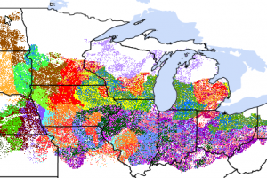
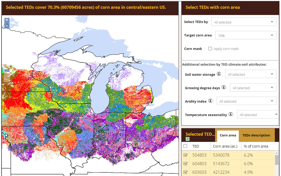
TED ties regions together based on these key growing conditions, not on proximity. Utilizing an existing approach developed by the University of Nebraska – Lincoln through the Global Yield Gap Atlas project, the framework is the first to provide a robust delineation of climatic and soil conditions across crop-producing regions in the United States.
The current version includes corn-growing regions in the U.S., and version 2.0 will include wheat-growing regions in the Western U.S. and Canada.
How it works
NutrientStar already lets farmers know which products have been tested on specific crops, what the results were (yield and fertilizer efficiency achieved, as well as profitability), how much research has been done on that product, and where it has been tested.
If a tool has not been tested in a farmer’s particular location, he can now go to the NutrientStar website and get information about areas of the Corn Belt where that tool has been tested that might correspond climate- and soils-wise to the area where he or she is farming. That’s because the framework divides up the Corn Belt and groups similar areas together by color. Areas with the same color indicate that a given product or management tool would perform similarly within that zone because soils and climate are similar.
Now, a farmer can find their specific location and the associated color of their operation’s geography. Looking at the TED framework, farmers can see other areas that have the same conditions and where the tool under question has been tested.
This comparison helps farmers – and their crop advisors – infer that a tool might work in their backyard, even if a field trial hasn’t been conducted at a nearby location.
Making the most out of field trials
The new framework can also help researchers who want to conduct field trials on a product or tool because it allows them to focus on locations where they would be able to get the biggest bang for their buck. In other words, it shows them which trial location has the greatest potential for extrapolating results out to other similar areas. Likewise, a manufacturer can now gauge certain conditions where a tool or product in development might be most effective.
We absolutely still need more data, transparency, and field trials from tool manufacturers to remove geographic limitations of assessments. While companies ramp up research, TED can help farmers interpret existing data more accurately – and makes NutrientStar a lot more useful for farmers across the Corn Belt.
Related:
If you’re marketing a product to a farmer, show them where and how it will work >>
New guidance to maximize every drop of fertilizer in Ohio and beyond >>
Why ag advisors should increase conservation offerings to farmers >>