Satellites become valuable new tool for governments, industry to cut emissions

 For years, people used satellites to observe the Earth’s climate. Now, orbital sensing offers a crucial new way to protect it, by giving us new abilities to identify, measure, and ultimately verify cuts in emissions of methane – a highly potent greenhouse gas.
Two new pieces of research led by EDF scientists demonstrate the growing potential of space-based monitoring tools, and offer a preview of things to come when EDF launches its own dedicated methane satellite in 2021.
Offshore Flaring in Mexico
First is a paper published this week in Geophysical Research Letters, explaining how researchers used space-based readings to calculate the enormous volume of natural gas being burned off (or “flared”) by oil and gas platforms in the Southern Gulf of Mexico. From 2005 and 2017, data from NASA’s Aura satellite show that operators flared as much as 710 billion cubic feet of gas per year.
The team was able to determine the amount of gas burned using satellite measurements of the sulfur- and nitrogen dioxide pollution coming from the flares – a scientific first.
Methane has more than 80 times the warming power of carbon dioxide (CO2) over the first 20 years after it’s emitted. Flaring converts much of the gas into CO2 – a massive climate footprint – but inefficient combustion means a considerable amount of methane continues to escape unburned, making the total climate impact of flaring many times worse. The practice is also incredibly wasteful. The gas flared by Mexico’s offshore operators in 2016 was four times the amount used by the country’s entire commercial, residential and public sectors.
Satellites become valuable new tool for governments, industry to cut emissions Share on XThe data show that flaring peaked in 2008, as operators ramped up oil production using methods that also yield large amounts of excess natural gas alongside the petroleum. Regulations introduced by the Mexican government in 2009 cut the amount of gas flared in half by 2017. While that marks a significant improvement, operators in Mexico are still burning off more than 40 percent of the gas associated with offshore oil production (compared with a flaring rate of less than three percent in U.S. offshore production).
This waste is happening even as Mexico imports tremendous quantities of natural gas from the U.S. and elsewhere because not enough domestic production finds its way to market. The satellite data shows is that aggressive steps to reduce flaring further could yield both environmental and energy security benefits.
Flaring in the Permian Basin
Separately, our team used data from a satellite operated jointly by NASA, the National Oceanic and Atmospheric Administration, and the Department of Defense to analyze flaring rates and volumes in the Texas portions of a sprawling oil and gas region known as the Permian Basin. EDF researchers found that operators there burned off more than 100 billion cubic feet of natural gas in 2017 alone – 4.4 percent of all gas produced, and nearly twice the 55 billion cubic feet that companies reported to state officials.
Some parts of the Permian are even worse. In the section known as the Delaware Basin, which accounts for about half of all gas produced in the Permian, satellite data shows operators burned almost eight percent of the gas they produced.
EDF’s satellite analysis lines up with a recent S&P Global Market Intelligence report, which also shows significant discrepancies between satellite data and industry-reported figures in Texas, North Dakota and New Mexico. Based on statewide readings from 2012 through 2017, S&P estimates that Texas wasted nearly a trillion cubic feet of gas through flaring, enough gas to supply every household in Texas two-and-a-half times over.
The Next Big Thing
Space-based measurements like these offer a glimpse into the near future. As more countries, like Mexico, adopt oil and gas methane regulations, and oil and gas companies announce methane reduction commitments, regular accounting for methane escaping across the global oil and gas supply chain becomes essential.
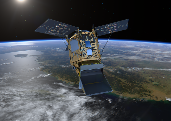
That’s why EDF announced last April that we are building MethaneSAT, a compact orbital platform that will map and quantify methane emissions from oil and gas operations and other human-made sources almost anywhere on Earth. It will provide the geographical scope and precision necessary to identify and assess problem areas previously unknown or poorly quantified, and measure changes in emissions over time.
MethaneSAT will be a tool industry and government alike can use to establish and verify reduction targets. Data will be available to the public at no cost, which will allow anyone to see the results of these commitments when action is taken.
MethaneSAT is designed to augment and deepen the information we are beginning to get from multi-purpose government-sponsored satellites already in orbit, and will provide necessary targeting information to a generation of satellites both government and industry are trying to develop that will track methane emissions at specific, known sites.
Methane from human activities is responsible for more than 25 percent of the warming the world is experiencing today. The oil and gas industry is responsible for somewhere between a quarter and a third of this. The International Energy Agency concludes that the industry can achieve a 75 percent reduction with today’s technologies (two-thirds of this at no net cost).
Reducing oil and gas methane emissions is the fastest thing we can do to slow the rate of warming now, even as the transition to a low carbon energy system continues. MethaneSAT and other new satellite technologies can help government and industry unlock this opportunity quickly and affordably, and with a new, much higher level of certainty.