How Economists Can Leverage MethaneSAT Data for Climate Action
This blog was co-authored by Maureen Lackner (Senior Manager of Economics and Policy Analysis, Environmental Defense Fund) and Lauren Beatty (High Meadows Postdoctoral Economics Fellow, Environmental Defense Fund).
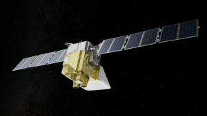
Climate change is a pressing issue, partly fueled by methane: a greenhouse gas responsible for about 30% of today’s global warming. Reducing methane emissions will slow down the rate of near-term warming and help avert the worst climate damages. To tackle this problem, Environmental Defense Fund launched MethaneSAT, the world’s first satellite developed by an environmental non-profit. MethaneSAT aims to quantify regional emissions of methane across more than 80% of oil and gas production in the world, while disaggregating diffuse area emissions and high-emitting point sources.
MethaneSAT will generate publicly available data allowing stakeholders to track emissions and hold polluters accountable. This data will empower various actors – governments, companies, and investors – to make informed decisions about emission reduction strategies. It will be an invaluable resource for economists and public policy researchers aiming to analyze and design effective climate policies.
Data Available from MethaneSAT
While MethaneSAT is not the first satellite designed to measure methane emissions, it fills a unique niche between the two existing satellite types: global mappers and point source imagers. This makes it an invaluable tool for tracking the overall changes in emissions both at high resolution and at regional levels and thus effectively informing policies and reducing emissions.
Global mappers such as TROPOMI and GOSAT were designed to provide global resolution of methane concentrations but have large pixel sizes and high detection thresholds. TROPOMI has a point-source detection threshold of many tons of methane per hour, making it capable of identifying only the most extreme emissions events (Laveaux et al., 2022). Point source imagers are designed to detect emissions from point sources and have smaller detection thresholds and pixel sizes. Moreover, since they are limited to narrow viewing domains, point source imagers do not provide regional or global emissions characterization (Jacob et al., 2022).
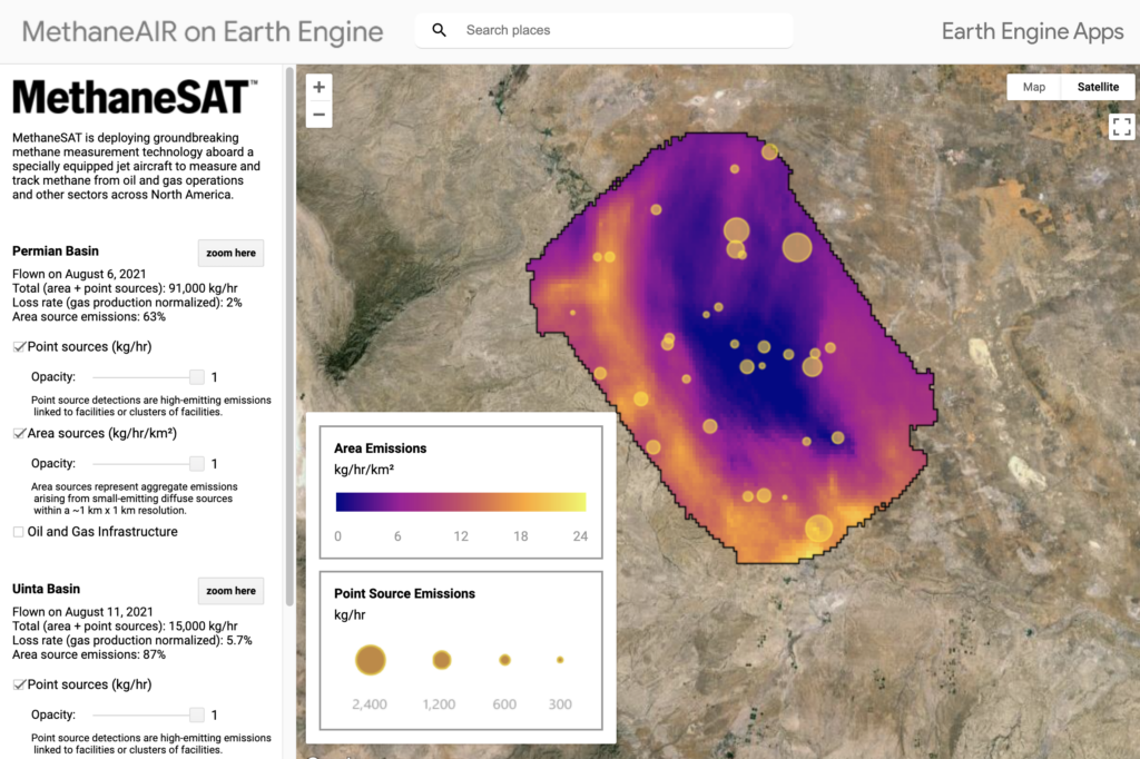
MethaneSAT will map and quantify emissions from the global oil and gas producing regions, while also spatially disaggregating diffuse area emissions at high resolution within individual regions, as well as detecting high-emitting point sources. Importantly, the data produced by MethaneSAT will be freely accessible for non-commercial applications, processed in an operational data pipeline, transforming methane concentrations to quantitative methane emissions through atmospheric inversion. MethaneSAT will provide area emissions, which will be diffuse emission heatmaps at high spatial resolution and high-emitting point source emissions. The combination of global coverage with a much finer resolution than global mappers will provide unique opportunities for research and emissions abatement.
A Brief Overview of the Economics of Methane Emissions
Methane emissions from the oil and gas sector are a classic example of what economists call an ‘externality.’ Externalities occur when individuals or firms cause harm (or benefit) to others that do not affect their own decisions. Methane emissions from oil and gas are primarily leaked natural gas. However, the price of natural gas on the market is far less than the social cost of methane emissions.
For context, for the past ten years, the Henry Hub spot price of natural gas has typically varied been between $2 and $4 per Mcf but the social cost of methane emissions from leaking natural gas is around ~$35 (see footnote 1). That means that operators do face some incentive to abate emissions, but their incentive is many orders of magnitude too low – methane emissions are ‘too cheap.’
Moreover, methane emissions from individual sites are expensive to measure and there are millions of oil and gas facilities across the globe. Environmental economists typically favor taxes to sensibly balance the benefits and costs of regulating pollution. However, when measurement is expensive, or emissions estimates are inaccurate, alternative measures like technology mandates may offer a more cost-effective means of pollution reduction.
Designing effective policy requires understanding firm incentives and considering all relevant costs, benefits, challenges, and opportunities. Economists have already thought long and hard about how incentives affect emissions and about effective ways to use policy to reduce methane emissions.
For example, a recent study on the provision of information on leaks to operators found evidence that informing operators of their small leaks made them less likely to fix them (Lewis et al., 2023). This is likely because the value of lost gas from small leaks is less than the cost of fixing them. Other research has demonstrated that constrained midstream capacity and/or market power may be an important cause of methane emissions from flaring (Agerton et al, 2023).
These results highlight the need for thoughtful regulation that considers the relationship between policies and incentives. To that end, economists have proposed solutions to improve the effectiveness of a methane emissions price, even in the absence of perfect measurement data. Such measures include targeted audits or built-in incentives for operators to report empirically measured and verified emissions data (Cicala et al., 2022; Dunkle Werner and Qiu, 2020) To encourage coordination across countries and ensure that ambitious countries aren’t put at a competitive disadvantage by their own policies, economists have proposed a methane border adjustment (Clausing et al, 2023).
However, there are still many outstanding questions on how to effectively regulate methane emissions given these measurement challenges and on how to operationalize these theoretically great ideas into actionable policy.
Using MethaneSAT Data for Better Policy
MethaneSAT will offer unique opportunities for public policy and economics researchers to build on this work by providing a new data source to inform policy design, evaluate policy effectiveness, and create new opportunities for policy implementation.
- Informing Policy Design: Policy is often guided and constrained by how costly the requirements will be for regulated agents relative to the social benefits of implementation. New empirical data on methane emissions from MethaneSAT can help policymakers understand the abatement costs of methane emissions, which will inform both sides of such cost-benefit analyses. Previous work has already shown that firms respond to increases in natural gas prices by reducing emissions – implying that putting a fee on methane can be an effective way to reduce emissions (Marks, 2022). New sources of emissions data can help researchers get even more precise estimates.
Emissions data from MethaneSAT could be combined with cost data on infrastructure upgrades to estimate the abatement costs of different technologies. These estimates can be used to help policymakers prioritize technology standards or investments in infrastructure upgrades.
- Evaluating Policy Effectiveness: The satellite will help researchers estimate the effects of policies aimed at reducing emissions, for example, the recently finalized US methane regulations, as well as proposed EU and Canadian rules, which include mandates for producers such as technology requirements, mandated leak detection surveys, and mandated reductions in the flaring of associated gas. Once these rules go into effect, policy evaluation based on measured emissions data will help inform even more cost-effective and equitable approaches in the future.
The wide swath of MethaneSAT enables such evaluation efforts to take place across the globe. This will be especially valuable in places with less environmental reporting requirements than the US, EU, and Canada. As new policies are implemented, economists may be able to use quasi-experimental variation to produce high-quality evidence on policy effectiveness or even run randomized controlled trials.
- Policy Design and Enforcement Regulators can use MethaneSAT data to inform policy implementation and enforcement in a timely manner. For example, the new methane fee created by the US Inflation Reduction Act will be assessed on emissions estimates from the US EPA’s Greenhouse Gas Reporting Program (GHGRP). Some of these emissions estimates are generated by taking equipment counts, then multiplying those numbers by “emissions factors” for various pieces of equipment. However, there is strong evidence that the current emissions factors are too low. New sources of emissions data will help policymakers improve their emissions inventories, which will in turn improve the effectiveness of the methane fee. New satellite data can also be used to understand levels and changes in methane emissions across space and time. In the same way that LandSAT data, and later more detailed remote sensing information, has allowed us to better understand deforestation and other land use patterns and changes, and design international policies on this basis, MethaneSAT data could be used to inform counterfactual baselines and assess potential leakage for methane emissions reduction crediting at sectoral or national scales.
We learned about and discussed many of these ideas at EDF’s recent 2024 EDF Methane Policy Research Workshop. In addition to hearing about research from economists around the world, the workshop included an overview of several projects run out of the Salata Institute of Harvard University’s Global Methane Initiative.
Methane Data for Everyone
MethaneSAT data will be available and regularly updated at no cost for non-commercial applications, including companies, governments, and the public. MethaneSAT’s commitment to timely and open-access data will generate benefits beyond what can be achieved by policy:
- The private sector can benefit from accessing MethaneSAT data to identify problem areas among their production facilities and determine cost-effective ways to reduce their own methane emissions. This means that the provision of MethaneSAT data may even reduce the marginal abatement cost curve, generating benefits for everyone.
- Investors can use data to guide their investment decisions.
- The public, including NGOs, can pressure companies and countries to reduce their emissions faster.
- Countries can pressure each other to increase their ambition to fight climate change by taking advantage of newly identified opportunities.
 Even before its launch, MethaneSAT has had a positive impact. The satellite has been instrumental in raising awareness of the methane issue, leading to several international pledges (such as the Global Methane Pledge, signed by over 150 countries aiming to cut their collective methane emissions at least 30 percent from 2020 levels by 2030) and company commitments (most recently the Global Oil and Gas Decarbonization Charter, in which 50 companies, including many National Oil Companies, pledge to reach near-zero methane emissions by 2050). And we will now be able to monitor the achievement of those pledges. We’ve seen increased investment in technology and ramped-up regulatory efforts from governments to reduce methane emissions.
With MethaneSAT now in space, we are all looking forward to harnessing the data it produces to spur climate action. Economists and public policy makers can leverage the hard work of countless scientists to inform the design and implementation of more effective policies, which can ultimately lead to a faster and more cost-effective reduction in global methane emissions.
Footnotes
- This calculation assumes that one Mcf of gas weighs 52lbs (though this will vary by temperature, pressure, and the composition of gas) and that the unit of natural gas is comprised of 80% methane. However, the composition of natural gas can vary widely across regions, and changes depending upon the production stage. This calculation also uses the EPA’s 2023 estimate of the social cost of methane of $1600 per ton using a 2% discount rate (EPA, 2022). Lastly, it ignores the social cost of other pollutants present in natural gas such as hazardous air pollutants (HAPs) or volatile organic compounds (VOCs).


